


This guide analyzes Beijing’s terrain of “mountains in the northwest, plains in the southeast” for foreigners, introduces natural landmarks like Dongling Mountain and Yongding River, and provides ecological tour routes with tips to explore Beijing’s natural charm.
When talking about Beijing, foreign tourists first think of the ancient capital landmarks with red walls and yellow tiles, but few know that the soul of this city lies in its mountains and rivers. With the terrain of “high in the northwest and low in the southeast” as its framework, Beijing is surrounded by mountains in the northwest as a natural barrier, and the open plains in the southeast nurture people’s livelihood. Rivers such as the Yongding River meander through, supplemented by the green space layout of “One Screen, Three Rings, Five Rivers, Nine Wedges”, creating a unique pattern of coexistence between nature and the city. Wandering along the mountains and rivers, you can not only climb to the peak to overlook the whole city, but also walk along the river to feel the beauty of ecology, understanding the other charm of Beijing beyond history.

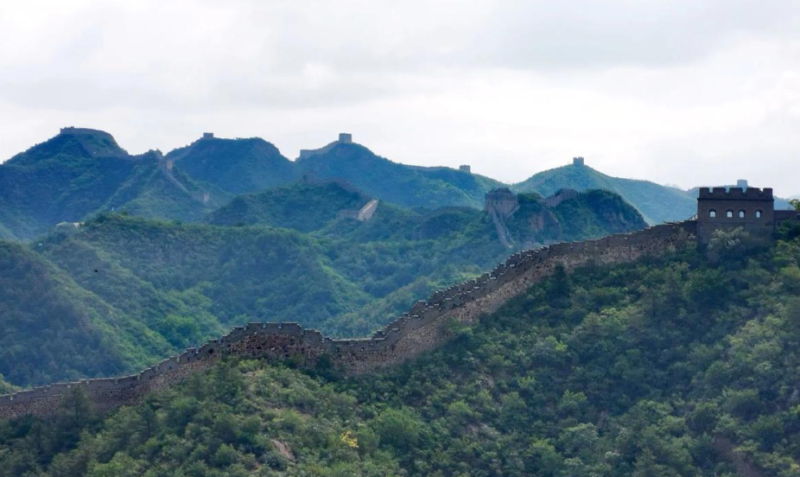
The terrain foundation of Beijing is a natural gift of “mountains in the northwest and plains in the southeast”. This pattern not only shapes the urban form, but also influences the wisdom of urban construction for thousands of years. The mountains on the northwest side are the spurs of the Taihang and Yanshan Mountains, with overlapping peaks like a natural city wall, which not only blocks the cold air and sandstorms from the north, but also provides rich ecological resources for the city. The southeast side is connected to the North China Plain, with flat and open terrain and fertile soil, becoming the core area for Beijing’s agriCulture, transportation and urban expansion. This pattern of “surrounded by mountains and rivers, with plains in the middle” endows Beijing with both the grandeur of mountains and the warmth and livability of plains, laying a natural foundation for the site selection and construction of capitals in past dynasties.
As the commanding height of Beijing’s terrain, Dongling Mountain is undoubtedly the first choice for exploring Beijing’s mountain scenery. This 2303-meter-high peak, the highest in Beijing, is located in Mentougou District, combining the steepness of northern mountains and the beauty of southern forests. The vegetation on the mountain is vertically distributed, from broad-leaved forests at the foot of the mountain to alpine meadows at the top, with distinct scenery in four seasons: blooming flowers all over the mountain in spring, cool summer resort in summer, layered red leaves in autumn, and snow-covered ice and snow wonderland in winter. For foreign tourists, climbing Dongling Mountain not only allows them to challenge the highest altitude in Beijing, but also overlooks the magnificent scenery of rolling mountains, feeling the pride of “climbing to the top”. It is recommended to visit in summer or autumn with professional hiking equipment. You can start from Jiangshuihe Village, enjoy birch forests, wildflower clusters and other landscapes along the way. The whole hike takes about 4-6 hours. The temperature difference on the top of the mountain is large, so you need to carry warm clothes. At the same time, pay attention to protecting the mountain ecology and not picking vegetation at will.
If the mountains are the skeleton of Beijing, then the rivers are the blood of the city. Among them, the Yongding River, known as the “Mother River of Beijing”, carries the ecological and historical memories of the city. Originating in Shanxi Province, the Yongding River flows through western Beijing, meandering between mountains and plains, providing water support for the early civilization development of Beijing and shaping characteristic landmarks such as the Lugou Bridge and Yongding River Forest Park. Today’s Yongding River Ecological Corridor has become a popular ecological tourist destination. Foreign tourists can go to Yongding River Forest Park, walk along the riverside trail, and enjoy the scenery of gurgling water and lush vegetation. The reed marshes and water-friendly platforms in the park are suitable for taking photos, and you can also encounter waterfowl habitats, feeling the harmonious coexistence between man and nature. In addition, as a landmark building on the Yongding River, the Lugou Bridge is not only a historical and cultural landmark, but also an excellent spot to watch the scenery of the Yongding River. You can combine natural sightseeing with historical visits to enrich the itinerary.

In addition to Dongling Mountain and Yongding River, Beijing’s five major rivers (Yongding River, Chaobai River, Beiyun River, Juma River, Juhe River) and the green space structure of “One Screen, Three Rings, Five Rivers, Nine Wedges” jointly weave the city’s ecological network. “One Screen” refers to the ecological barrier in the northwest mountainous area, “Three Rings” are the urban green belt, suburban green belt and mountain green belt, “Five Rivers” are the ecological corridors of the five major rivers, and “Nine Wedges” are nine ecological wedge-shaped green spaces extending from the suburbs to the city. This structure not only improves Beijing’s ecological environment, but also creates many high-quality ecological scenic spots. For example, Chaobai River Forest Park, built along the Chaobai River, is the largest wetland park in northeastern Beijing, suitable for cycling, camping and parent-child trips; the Shidu Scenic Area along the Juma River is famous for its karst landforms and river valley scenery, making it an excellent place for hiking and rafting, allowing foreign tourists to deeply experience the natural diversity of Beijing.
The construction of this ecological network has also directly promoted the normalization of “Beijing Blue”. The one-million-mu afforestation project has continuously improved the forest coverage rate in mountainous areas, and the green corridors have effectively purified the air and regulated the climate, transforming Beijing from “smog-stricken” to an “ecologically livable city”. During the tour, foreign tourists can not only feel the fresh air and blue sky, but also learn about the achievements and wisdom of Beijing’s ecological governance through the popular science signs in the scenic spots.
A practical two-day itinerary connecting landscape attractions can be planned: on the first day, focus on mountain scenery, go hiking in Dongling Mountain in the morning to experience the peak ecology and magnificent scenery, and visit Yongding River Forest Park on the way back to the urban area in the evening to enjoy the sunset by the river; on the second day, delve into rivers and wetlands, visit the Lugou Bridge and the banks of the Yongding River in the morning, and go to Chaobai River Forest Park in the afternoon to experience leisure activities such as cycling and camping, immersing yourself in the natural ecological beauty of Beijing. During the tour, it should be noted that most mountain and river scenic spots rely on public transport connections. You can check the special bus information in advance, carry sunscreen and insect repellent, respect the ecological environment, and jointly protect Beijing’s landscape resources.


暂无评论内容